North Cascades Hiking Guide: Our Top Trail Picks
The Cascades are a mountain range that spans from British Columbia in Canada, then through Washington and Oregon before ending in Northern California. This adventure guide highlights our favorite trails in the North Cascades region in Washington, between the Canadian border to the north, extending to the Stevens Pass/Highway 2 area to the South. The geography in this area is known for its rugged peaks and deep, glacial valleys. Nicknamed the “American Alps,” it contains some of the most vast stretches of wilderness in the lower 48 of the U.S. You will not be disappointed by the natural wonders this region has to offer.

This guide will divide our favorite adventures into different regions of the North Cascades:

Pink Oval = Mountain Loop Highway; Blue Square = Methow Valley area
Mount Baker Area
Chain Lakes Loop
- TRAIL STATS:
- 6.5 miles roundtrip
- Moderate; 1,820 feet elevation gain
- Passes/permits: Northwest Forest Pass
- Dogs are allowed
- This is one of our all-time favorite Washington hikes to date! On a clear day, you’ll have views of Mount Baker and Mount Shuksan, and several alpine lakes to dip your toes in. We did this as a day hike in early September (when the fall colors were starting to arrive), but there are many established campsites along this trail as well if you wanted to backpack it. We stayed in the cute town of Glacier as our home-base. This would be a fantastic hike in the summer for wildflowers as well!
- Note that there are several access points to this trail from Mt. Baker Highway. We like to start at the Bagley Lakes Trailhead, which is in the Mount Baker Ski area, and is the first trailhead you’ll come across along Mt Baker Highway after you leave Picture Lake. If this parking lot is full, you can continue along Mt. Baker Highway to Austin Pass Picnic Center (also known as Heather Meadows Visitor Center) for more parking options, or even further on to the end of the road at Artist Point (which has a HUGE parking lot).


Picture Lake
- TRAIL STATS:
- 0.60 miles
- Easy; little to no elevation gain, ADA accessible path from the road
- Passes/permits: Northwest Forest Pass
- Dogs are allowed
- What a picturesque lake! We actually stopped here for a few sunrise photos before driving a few miles along Mt. Baker Highway to the Bagley Lakes Trailhead to hike Chain Lakes Loop (see above). Highly recommend combining these trails since they are in the same area!

Artist Point
As mentioned above, Artist Point is the last viewpoint at the end of Mt. Baker Highway, and is part of the aforementioned Chain Lakes Loop trail. However, Artist Point is mostly famous for its epic snowshoe views, so check out our other post HERE for details about making this a winter adventure.

Park Butte Lookout
- TRAIL STATS
- 7.5 miles roundtrip
- Moderate; 2,200 feet elevation gain
- Permits/passes: Northwest Forest Pass
- Dogs are allowed
- This is a fun hike to a historic lookout where you can get up close and personal views of the great Mount Baker (Koma Kulshan), passing by many lush meadows and campsites along the way. We did this hike in mid July and the wildflowers were just starting to bloom.


North Cascades Highway (Hwy 20) + North Cascades National Park
Diablo Lake
- TRAIL STATS:
- Overlook from road, no trail
- Permits/Passes: none
- This is the classic scenic viewpoint that usually comes to mind when one thinks of the North Cascades National Park. You can drive right up to this overlook along Highway 20, Milepost 131.7. The vibrant color of the lake is due to glacial flour, fine small particles suspended in the water, which absorb light in such a way that results in these distinct jewel tones that we see, especially on a sunny summer day.

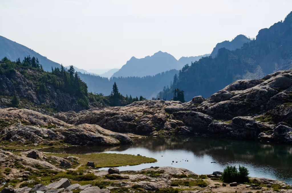
Heather-Maple Pass Loop
- TRAIL STATS:
- 7.2 miles; 2,000 feet elevation gain
- Moderate
- Permits/Passes: Northwest Forest Pass
- Dogs are allowed
- This is a very popular trail that is a fan favorite almost year-round: spring for the wildflowers, summer for the classic mountain views, and fall for the larches and colors. We did this in early September and opted to do it counter-clockwise. The views are fabulous, but definitely expect to share the trail – this is guaranteed to be crowded.


Sourdough Mountain
- NOTE: as of 3/2025 this trail is still closed due to damage from the 7/2023 Sourdough wildfire
- TRAIL STATS:
- 10.4 miles roundtrip
- Strenuous; 4,800 feet elevation gain
- Permits/Passes: None
- Dogs are NOT allowed
- This trail goes up, up and up to a historic fire lookout with incredible panoramic views of the surrounding mountains. This is definitely a tough climb, but the reward at the summit is worth it, if you’re up for the challenge.


Hidden Lake Lookout
- TRAIL STATS:
- 8 miles roundtrip
- Moderate to strenuous; 3,300 feet elevation gain
- Permits/passes: None
- Dogs allowed
- This trail will take you to another historic lookout that you can backpack to and stay in overnight for a small donation (first come, first serve). We did this as a day hike October 2019, when the transition from fall to winter was crisp in the air. The summit provides breathtaking, panoramic views of the Cascades in every direction.


Mountain Loop Highway
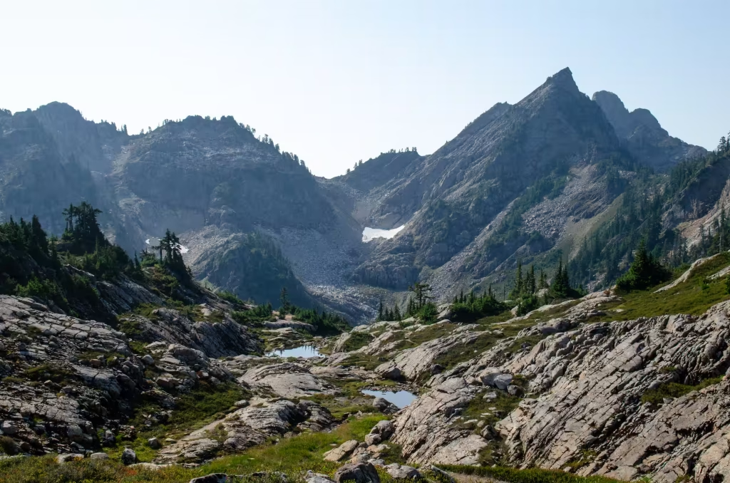
Gothic Basin
- TRAIL STATS:
- 10 miles roundtrip
- Strenuous; 3,000 feet elevation gain
- Permits/passes: Northwest Forest pass
- Dogs allowed
- Many folks backpack this trail, but we decided to do it in one day with our dogs on a glorious, sunny day in early September 2025. We trail ran the flat sections (approx. first 2 miles) and hiked the steeper sections. Most of this hike is forested with a few opportunities for peek-a-boo views of the surrounding peaks, but the best views aren’t until you reach the Gothic Basin saddle. There is ample water access along the way (a river in the beginning, and multiple creeks and one large waterfall mid-way up). First you’ll reach Gothic Lake, but keep pushing a little further (a half mile) through a rocky section to reach Foggy Lake. It took us 3 hours to reach this point, and we enjoyed lunch and a quick swim here before turning around.
Heather Lake
- TRAIL STATS:
- 5 miles roundtrip
- Easy to moderate; 1,000 feet elevation gain
- Permits/passes: Northwest Forest Pass
- Dogs allowed
- This is a popular trail because it is easy and short enough for families with young children to attempt, but with its rooty and rocky trail, still enough of a challenge for those that are new to hiking or looking to level up. It is also much more accessible than other trails in the North Cascades as it is a shorter drive from Seattle compared to more remote trailheads on this list. There are a few established campsites, and in the summertime, you can find many people finding reprieve from the heat by jumping into the lakes that give this trail its name.


Lake Twentytwo
- TRAIL STATS:
- 5.4 miles roundtrip
- Easy to moderate; 1,300 feet elevation gain
- Permits/passes: Northwest Forest Pass
- Dogs Allowed
- This trail is just down the road from Heather Lake (above), has similar trail specs, and therefore is also just as crowded. We did this on a weekday in late October and were greeted with fall colors on a sunny day. The pristine lake engulfed by it’s surrounding mountains is certainly a sight to see, and you’ll understand why it is a popular trail.


Methow Valley area (eastern slope)
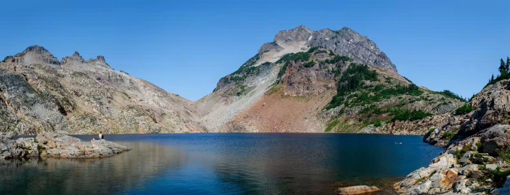
Crater Lakes
- TRAIL STATS:
- 8.6 miles roundtrip
- Moderate; 2,200 feet elevation gain
- Permits/passes: Northwest Forest Pass
- Dogs allowed
- In the Fall, we like to venture to the eastern slope of the North Cascades for multiple reasons: this is the drier, sunnier side, and the fall colors and golden larch trees are an incredibly beautiful thing to witness. This also means this is quite a far drive from the Seattle area, so we did this as a one-night backpack trip. Check out our other post HERE for other Fall Colors & Larches trail recommendations


What’s on our bucket list in the North Cascades?
- Cutthroat Pass for fall colors & larches
- Cascade Pass to Sahale Arm
